|
|||||||||||||||
|
South Cow Mountain OHV Recreation Area is 60,000 acres of BLM land located between Ukiah and Clear Lake in Northern California. The area is split into two sections. North Cow Mountain is reserved for hiking and target shooting, while South Cow Mountain is open for OHV use. South Cow Mountain is open almost every day of the year and offers good riding most days. Remember to always call ahead to ensure that the area will be open when you plan to be there. The BLM web page for Cow Mountain is located at http://www.ca.blm.gov/ukiah/cowmtn.html and includes all contact information and directions on how to get there from Ukiah or from Lakeport.
Cow Mountain maps are available through the Ukiah field office of the BLM and are usually posted in the map box at the first staging area when entering the OHV area from Ukiah. The map box is located next to the information board on the unloading side of the parking lot. The main staging area has primitive bathrooms, covered picnic tables, a paved parking area and two very nice loading docks. Cow Mountain is a mix of fire roads, jeep trails and single-track trails. Many of the roads and trails in the Southern part of the OHV Area offer incredible vantage points of Clear Lake. Depending on the air quality and the elevation of the trail, it is sometimes possible to see most of the way to Sacramento.
The trails at Cow Mountain range from very easy (Mendo-Lake Road) to very difficult (particularly the trails off of the main road on the Clear Lake side of the area. About 40
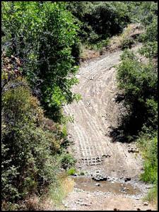
My favorite time to ride Cow Mountain is from mid spring through late summer. Due to the high temperatures most of the crowds stay away, but the seasonal streams often continue flowing through July and into August, leaving many challenging stream crossings and no wait to try them. Seasonal high temperatures in the summer can exceed 110 degrees, but because the OHV area is at the top of the mountain range and only about 35 miles from the Pacific Ocean, there is often a cooling sea breeze flowing through the area. In spring, when the rains stop, and in fall just after the first rains, South Cow Mountain can get very crowded, but these seem to be the only times that there are large numbers of people in the area. Visitors to the South Cow Mountain OHV Area will be treated to a wide variety of terrain. The average trail consists of relatively easy jeep trails that eventually lead to steep, rocky, rutted hill climbs, slippery stream crossings, shale hills, boulder fields, tunnels of brush and trees, and root infested switchbacks. There are no directional designations for the trails at Cow Mountain, so always be prepared to find someone coming at you. On the steep technical stuff (some of it very steep and very technical indeed) it is wise to look ahead, or even shut off your motor and listen to see if anyone is coming the other way.
Aside from the
main access roads, Cow Mountain is no place for beginners. A good rule
of thumb is that if you have any difficulty negotiating Trail 1 from the
main staging
area to Red Mountain, you will also struggle on most of the trails
marked as Medium Difficulty. This also means that if you see a trail
marked with a Black Diamond (Most Difficult) you should take this very
seriously. Don't rely on the BLM Trail Map for accurate difficulty
ratings. You will find that the trails are well marked and that many of
the trails marked Medium on the map have Black Diamond sections that are
clearly marked on the trails, but not the map. Some of the trails go on
for many miles and will offer challenges to riders of any skill level.
And some of the more difficult trails could take anywhere from 2 to 5
hours depending on when it last rained. Did I mention steep hills? Cow Mountain is an area of very rugged terrain. Many of the trails feature climbs and descents that will test your skill. It is always good practice at Cow Mountain to ask yourself whether you could get back up what you just came down, or vice versa, before you attempt anything because there are obstacles that are sometimes impassible and you just might have to go back the way you came. Always keep in mind that if you go up you will eventually have to come down. This is particularly important at the water crossings as some of them feature very steep and slippery slopes going both ways and require absolute commitment before you hit the water at the bottom of the canyon.
And the water that turns into mud, how about that? At Cow Mountain there are some soils that hold water and others that don't. In the areas that do hold water it is important to watch out for mud holes. I spent two hours pulling my bike out of a mud hole last year just to have to cross ten more on the way back to the road. A good rule of thumb is that if it looks deep, it probably is, and if there is evidence of people having struggled to get through, then you will too. If there is a way to walk your bike through or around one these obstacles, take it. This is really only a problem in the mid to late Spring when the large puddles have had lots of traffic. Once you have established for yourself that you really do know your limits and that you are ready to tackle terrain that will make grown men cry, you will be well on your way to discovering what Cow Mountain really has to offer.
|


|
Off-Road.com Newsletter Join our Weekly Newsletter to get the latest off-road news, reviews, events, and alerts! |
Follow @Off-Road
 Your Privacy Choices